ESWATINI NATIONAL TRUST COMMISSION
Conserving Eswatini's Natural and Cultural Heritage

The ENTC now has a new website, at www.entc.org.sz
Our logo is adapted from a painting by Phillip Dlamini, 1998, of a purple crested turaco. In traditional Swazi dress, the red feathers feature in the royal headdress, so this bird illustration is not only a symbol for wildlife conservation, but also of cultural heritage.

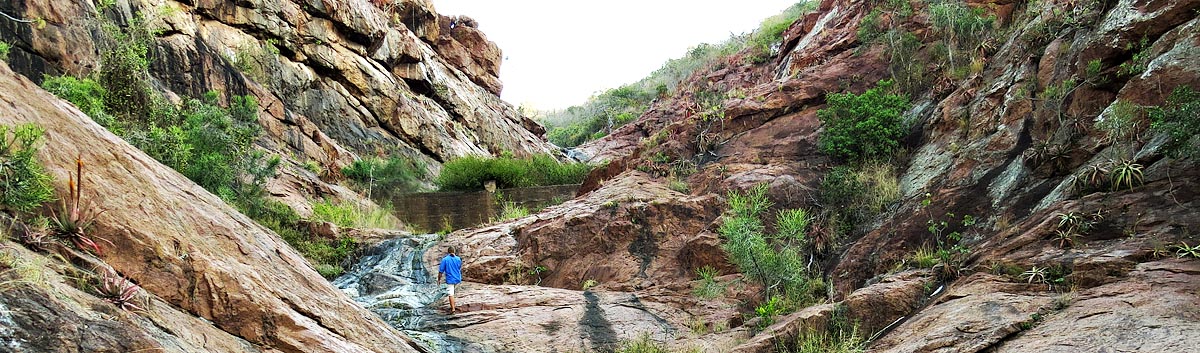
It is believed that after the African continent was left in isolation its surface began to erode. In the course of tens of millions of years, the surface was reduced to a pleneplain known as the African Planation Surface (King 1963). This plain, irrespective of the underlying geology, dipped towards the Indian ocean at an angle of 5 degrees. Across this landscape, mature rivers meandered in broad tracks. However, margin uplift, possibly in the Miocene times of 20 million years ago (Maud and Partridge) led to gradual lowering of these river tracks within their original meandering beds. This caused the etching of the preweathered weak rocks and engorgement of the meanders in the resistant rocks. It is at least during the last 20 million years that the Lowveld has been eroded (Watson and Price Williams 1985) and the Mlawula and Mbulizi gorges have cut down through the Lubombo. This is true of all the rivers flowing through the Lubombo Range. Evidence of remnants of the old African surface can still be seen on the Lubombo crest at Ndzindza where views north and south, particularly towards Mananga, show vestiges of a lightly dipping surface to the east. It may be noted that this is not a function of the bedding planes of the underlying rocks since they are dipping in a generally eastern direction as well, but between 30 and 40 degrees to the east (Cleverly 1979). This surface is picked up again in the extreme western portion of Swaziland (Watson and Price Williams 1985).
On top of the Lubombos are a number of closed depressions or pans, especially along the ridge on Ndzindza. These pans, which retain water and frequently contain iron concrete, are located on remnants of the African planation surface and were probably formed within the last million years. Their origin is associated with the rhyolite which produce zones more susceptible to weathering (Watson 1986).
More recent geomorphological evidence is to be noted along the valleys of the Mlawula and Siphiso rivers. Sloping pediments from the base of the ridges towards the river beds are mantled with colluvium. Colluvium is a weakly sorted mixture of sands, silts, and clays believed to have been emplaced during the terminal Pleistocene some 20 thousand or more years ago (Price Williams; Watson and Goudie 1982; Price Williams and Goudie 1984). This sediment originates from the denudation of the backslope and the formation of colluvial fans resting at angles of about five degrees and reaching thicknesses of several metres. These colluvial sediments, which appear to have clogged drainage lines, were probably formed in climatic conditions quite different from the present day. Subsequent re-establishment of the river beds often exposes sections of colluvium. The colluvium is often underlain by cemented gravels, obviously older, but of indeterminate Pleistocene age.
Overlying the colluvium along parts of the rivers is a large silt river alluvial terrace. The terrace is often many metres thick and forms a flat zone adjacent to the present river course. On the Umbuluzi, it is noticeable along on both sides of the Siphiso river near the rest camp and especially on the inside of the large meander near the airstrip (upstream of its confluence with the Mlawula). The rest camp is built on this terrace. During Cyclone Domoina, the terrace was overbanked but was neither eroded nor added to. This implies that it formed in somewhat different conditions earlier than today during the Holocene epoch (last 12000 years). The most recent geomorphic activity is associated with coarse sands which form part of the present riverine floodplain. These are periodically mobilized and redistributed during flood conditions.
Our Contacts:
Head Quarters: (+268) 2416 1489/1179
Email: info@sntc.org.sz
King Sobhuza II Park: (+268) 2416 1489/1179
Email: ksmp@sntc.org.sz
National Museum: (+268) 2416 1489/1179
Email: curator@sntc.org.sz
Copyright © ESWATINI NATIONAL TRUST COMMISSION
Malolotja Nature Reserve: (+268) 2444 3241 / (+268) 2416 1480
Email: culturalvillage@sntc.org.sz
Mantenga Nature Reserve and Swati Cultural Village: 2416 1151/1178
Email: culturalvillage@sntc.org.sz
Mlawula Nature Reserve: (+268) 2383 8885 (Reception)
(+268) 2383 8453 (Senior Warden)
Email: culturalvillage@sntc.org.sz
Magadzavane Lodge: (+268) 2343 5108/9
Email: magadzavane@sntc.org.sz
Follow us on Facebook